One of California's Best Freestone Streams
About 35 years ago while I was attending Sonoma State College and residing in Santa Rosa, I picked up the San Francisco Chronicle and read Jim Freeman's outdoor column. He had just returned from a fishing trip on the Upper Sacramento River, and he outlined his success on the river fishing with Ted Fay, a Dunsmuir angler and fly tier who had gained a reputation as one of the most knowledgeable anglers on the Upper Sac. Black and brown weighted Woolly Worms and Woolly Buggers in tandem dabbed and dropped along the sides of boulders both submerged and rising above the water column were tactics that produced then and will produce today. The next weekend I rushed up to the Upper Sacramento River to Dunsmuir and located Ted Fay's home. Ted was on the river fishing, but his wife invited me inside. I asked if I could buy a few of Ted's flies. The small living room was cluttered with fly tying equipment and supplies. In the center of the living room was an "Archie Bunker" chair with a table and vise which faced the television.
"Do you know what pattern, size, color that you want?" his wife asked.
"No," I replied. "I only know how to fish with dry flies. I'll just take whatever you recommend."
"Well, I would recommend whatever he has left next to his vise. That's what he will be using today. When I returned home, I immediately ordered a Thompson vise and supplies from a Herter's catalogue, and along with a book on fly patterns began copying my few remaining Ted Fay flies. With the river's recovery after the infamous chemical spill by the railroad in 1991, I could find little change. What I did find was beautiful stretches of a small, freestone stream that stretches almost thirty-five miles from Lake Siskiyou to Lake Shasta. The only difference I experienced was my own difficulty in wading and scrambling down embankments. When I see men in their 70's out in the middle of a rocky-bedded stream, I sigh with resignation uncertain if I will be able to do the same in ten years.
Although I trekked up and down the river in November and managed to catch a late afternoon caddis hatch and some lone giant October Caddis which put the little fish on the bite, most authorities recommend waiting for spring run-off to subside, noting that late May and June are the early summer kick-off months for fishing the Upper Sacs riffles, runs and beautiful pocket water. Considering the vagaries of snow melt and arrival of insects, anglers in the early summer months are typically greeted by hungry trout and plentiful hatches of stoneflies, caddis and mayflies. Wading in November, my cold, numb feet reminded me that the river is a tailwater, freestone river, and the water that comes out of the lake and drops down into the dark canyon remains cold, in spite of the balmy 70-degree air temperatures. The river also gains more volume of water from tributaries before it meets the lake.
With the help of the Shasta /Trinity Forest Service website, and the StreamTime map, Upper Sacramento River Access, I was able to discover numerous good access points right off Interstate 5. The Forest Service website also offers a hatch chart with suggested patterns courtesy of The Fly Shop. Almost every exit off the interstate leads to good fishing waters. I have included most of these exits. The fishing map can be purchased at Ted Fay Fly Shop in Dunsmuir or The Fly Shop in Redding. Ted Fay Fly Shop's new address is 5732 Dunsmuir Ave., Dunsmuir, CA 96025, or they may be reached at (530) 235-2969. www.tedfay.com.
http://www.fs.fed.us/r5/shastatrinity/recreation/st-main/st-fishing/rivers/upper-sacramento.shtml
Access Points Northbound on Interstate 5 from Lakehead to Box Canyon Dam above Dunsmuir

Note: Much of the phrasing for directions is taken directly from the forest service website, which is not copyrighted.
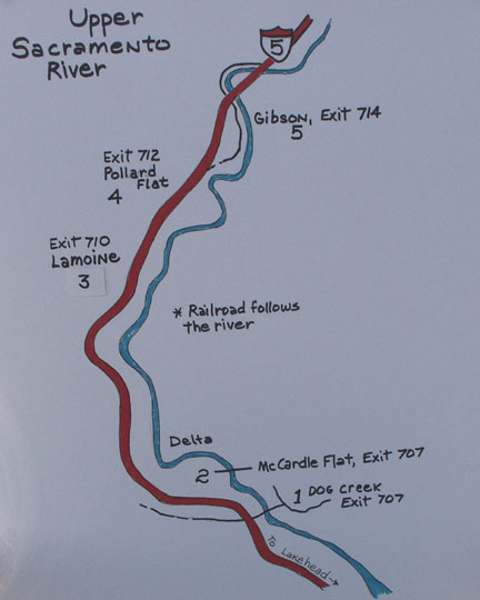
1. Dog Creek: Traveling I-5 Northbound, take the Vollmers exit #707. Turn left on Dog Creek Road/Delta Road, and go under the freeway. Travel 0.3 miles and turn left on Fender Ferry Road. Travel approximately one mile down Fender Ferry Road under the freeway bridges, cross railroad tracks and cross a one-lane bridge over the Sacramento River. Park along road after crossing bridge. Walk down the dirt road to the right for river access. You will find some long runs and slow pools during low water.
2. McCardle Flat: Take Vollmers exit 707. Turn left onto Dog Creek Road/Delta Road. Turn right on Delta Road, then turn left onto McCardle Flat Road. Travel 1.0 mile down McCardle Flat Road and turn right onto a gravel road. Go approximately 0.4 miles down the graveled road and park in widened area near railroad tracks, or you may take the dirt road to the right that leads to a parking area downstream with a turn-around and a primitive spot for camping. (The railroad track is very close for those of you who are light sleepers or have sleep disorders!)
3. LaMoine: Take the LaMoine exit. Travel 0.5 mile and turn left at first dirt road (across street from school bus sign on right). Dirt road forks, take right over bridge (Slate Creek). Travel approximately 0.2 miles on dirt road and park along road at top of hill. Walk down the dirt road to the left and head east to the river.
I watched this angler catch two small trout in less than ten minutes on a small dry fly.
4. Pollard Gulch: Take Pollard Flat exit. Turn right at the stop sign. Turn left on Eagle Roost Road. Take an immediate right and follow to a parking area for seven vehicles (Note: No parking spaces for large RVs or trailers). This is a USFS picnic and day use site.
5. Gibson: Take the Gibson exit #714. Follow the road as it circles over the freeway heading south; the road parallels the freeway heading south, then goes east under the freeway, and then parallels river. Park along Gibson Road and walk to river. The further the road heads south, the higher the road is from the river. If you continue, it will meet up with the Pollard Gulch access.
Sims Footbridge, a Civilian Conservation Corp project

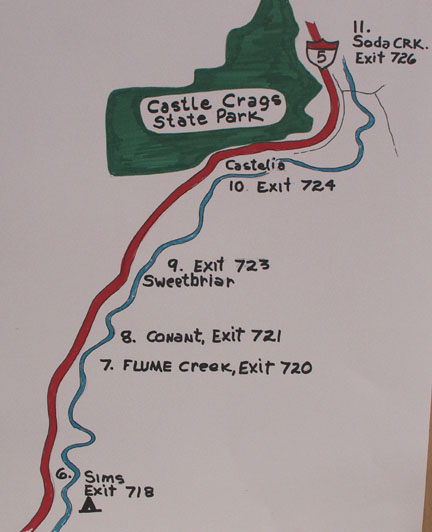
6. Sims: Take Sims exit #718. Turn right on Sims Road. Cross railroad tracks and bridge over Sacramento River to a parking lot near a pedestrian bridge. The Sims USFS campground is beautiful and right on the river. The cost per night is $12, but the daily fee will rise to $15 for the 2008 season. The campground closes on the last day of the general fishing season, November 16. I really liked this old campground, but just at the base of the hill is a dirt road that leads back to some railroad land and a primitive camping area with shade. Hey, when you are retired, these are the spots I look for to camp. Right across the tracks is a mini rock gorge, and above it is some nice riffle and run water. (I had some smaller trout torment me here.)
7. Flume Creek Exit: Just before Flume Creek Exit #720, is a large pull-out just off Interstate-5. Follow the open gated road down the hill and downstream along the railroad tracks to Flume Creek. This area offers some great fly fishing water downstream, but I never checked upstream.
8. Conant: Take Conant Road exit 721. Turn right on Conant Road. Turn right at first dirt road. Park on the west side of railroad tracks. Walk east to the river.
9. Sweetbriar: Take exit 723. Trailers and RV's are not advised on this paved road. Do not cross the one-lane bridge. Park before the bridge. Here is a community that is open to sharing their section of water as noted on a sign. Personally, I wouldn't feel comfortable fishing with someone peering down at me from a deck as I muffed a cast or slipped on a rock.
10. Castle Crags State Park: Take the Castella / Castle Crag exit #724. (Chevron gas station) The state run campground is open year-around on a self-register payment system of $15 per night and $6 for day use parking. It has sites that will accommodate 27' RV's and 24-foot trailers, as well as tent camping. During the summer it can be filled up. For reservations call 1-800-444-7275. The park also has a picnic site across the river. Late in the fall there is not much water here, but in the summer it supposedly fishes very well. Fork up the six bucks because there is no other parking at the picnic site.
11. Soda Creek: Take the Soda Creek exit #726, about 2.5 miles below Dunsmuir. I had two friendly residents of the area direct me to Soda Creek. This was especially heart felt since I had a local give me the "Kiss-my-ass" gesture when I was exiting Scarlet Way! Since I was stopped, I was puzzled by his animosity. Was it the Oregon plates? Well, there are assholes everywhere that don't want to share. I will remember the two people who gave me unsolicited fishing tips - thank you, guys. Park in the dirt pull-out just before the bridge. Walk downstream past the chained fence and follow the path to a curve in the river that offers a big pool up against a cliff at the base of a riffle.

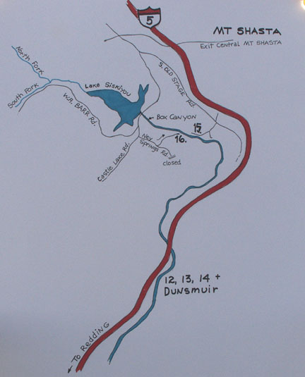
12. Dunsmuir City Park: Traveling I-5 Northbound, take Central Dunsmuir exit. Turn left onto Dunsmuir Avenue. Travel 0.5 miles and turn left at "Dunsmuir City Park" sign. Follow the road down to the park. Note: The town of Dunsmuir offers numerous access points to the river such as the I-5 Pool and the access at Financial Avenue. Tauhindauli Park is in central Dunsmuir and a paved road leads down to the water. No RV's, buses or semi-trucks allowed. (This is close to Ted Fay Fly Shop.)
13. Scarlet Way, Dunsmuir: Take Central Dunsmuir exit. Turn left onto Dunsmuir Avenue. Travel 0.8 miles and turn left on Scarlet Way. The road sign is easily missed, but you will see the brass metal sign for Shasta Retreat that arches over the road. Turn right on Cave Avenue. Cross river and railroad tracks, turn left after tracks to dirt parking area. The road here is narrow and winds through a neighborhood.
14. Prospect Avenue, Dunsmuir: From the northbound lane of I-5, take the Dunsmuir Avenue exit #732. Turn left at the stop sign. Travel 0.3 miles and turn right on Prospect Avenue. (Look for the Prospect Avenue Fishing Access sign.) Turn right when the road forks and proceed to the bridge and the parking area. (Narrow road.)
15. Cantara: To locate the Cantera Fishing Access area, exit from I-5 at Central Mt. Shasta. Turn left at the stop sign on Lake Street and proceed over the interstate until it intersects Old Stage Road. Travel 2.5 miles and cross Azalea Road, veering right to continue on Old Stage Road. Travel 0.25 miles and turn right on Cantara Loop Road. Follow the dirt road down some switch-backs to the dirt parking area. (Picnic area) Note: Just as you are descending down the road, you will note a road on the left with an open gate and no restrictive signs. This rough road leads down to the railroad bridge in a picturesque meadow. A commemorative sign acknowledges all the efforts that went into the clean up and restoration of the river after the chemical spill that took place in the vicinity. I found a nice unimproved campsite with no restrictive signs, but don't tell anyone I said you could "park" for the night. This is a beautiful area, and if you are cautious and wary, you can hike the railroad tracks upstream or downstream to reach less pressured areas of the river. Keep in mind, however, that some of the bridges and narrowing restrictions provide no escape for old farts like me who stumble along watching their feet. When you are my age, you have to hark back to kindergarten warnings: stop, look and listen!
16. Ney Springs: Although the forks of the Upper Sacramento River above Lake Siskiyou offer small fish in small water, for all practicality the Upper Sacramento River is considered to be the outlet of Lake Siskiyou as it plunges out of the lake and down into the steep Box Canyon. The basalt gorge is, practically speaking, impassable. A couple miles down this twisting 100-foot steep walls of rock is the first access to the river. Ney Springs, with its cold water pulled from the bottom of the lake and its infusion of cold spring water, offers a prolonged mayfly hatch during the summer. Conversely, in the fall more optimum water temperatures may be found below the town of Dunsmuir. To locate the Ney Springs access area, exit from I-5 at Central Mt. Shasta. Turn left at the stop sign on Lake Street and proceed over the interstate until it intersects Old Stage Road. (Directly ahead is a fish hatchery.) Turn left on Old Stage Road and then veer right on W.A. Barr Road and cross over Box Canyon Dam. In less than two-tenths of a mile, turn left on Castle Lake Road. Take the first available left turn on a dirt road and travel 1.25 miles, and then turn left at sign that reads Cantara / Ney Springs Wildlife Area. The dirt road is narrow and leads down through a series of switch-backs. (No camping restriction)
General Fishing Regulations 2007:
Open last Saturday in April to November 15
Zone 1: Dam to Scarlet Way in Dunsmuir; zero trout, artificial lures, barb less hooks
Zone 2: Scarlet Way to Sweetbriar - 5 trout, no special gear
Zone 3: Sweetbriar to Lake Shasta - 2 fish, artificial lures, barb less hooks
Zone 2 and 3 are open during the winter with zero limits, artificial lures only and barb less hooks.
Please read current regulations for any changes or restrictions.
Hey! Yes, you! I'm writing all this stuff and wondering if anyone actually reads it. I'd love to get some feedback on any of my articles. Email dave@glaciertoyellowstone.com. Thanks!